Full Text (PDF)
Indian Journal of Plant and Soil 10(2):p 49-68, JULY-DEC 2023. | DOI: https://doi.org/10.21088/ijps.2348.9677.10223.1
Original Article
Geoenvironmental Suitability Assessment of Three Agroecological Systems in India
Author Information
Licence:
Attribution-Non-commercial 4.0 International (CC BY-NC 4.0)This license
enables reusers to distribute, remix, adapt, and build upon the material in any
medium or format for noncommercial purposes only, and only so long as
attribution is given to the creator.
Indian Journal of Plant and Soil 10(2):p 49-68, JULY-DEC 2023. | DOI: https://doi.org/10.21088/ijps.2348.9677.10223.1
How Cite This Article:
Bhaskara Phaneendra Bhaskar. Geoenvironmental Suitability Assessment of Three Agroecological Systems in India. Ind J Plant Soil. 2023;10(2):49-68Timeline
Received : June 06, 2023
Accepted : July 29, 2023
Published : December 25, 2023
Abstract
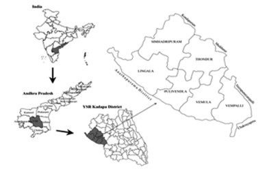
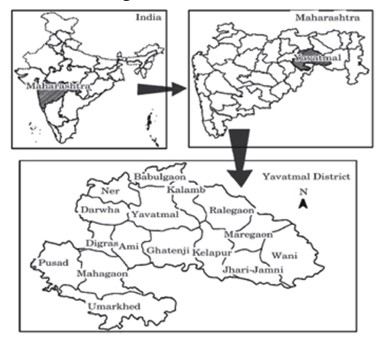
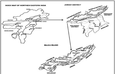
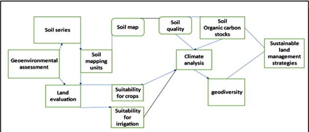
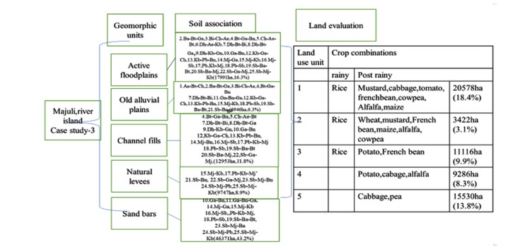
The geo-environmental assessment is a prerequisite for adopting agro-ecological principles and achieving sustainable crop yields. We present three case studies from three agro-ecological regions. Pedological data sets were made and used to evaluate bio-physical parameters in Pulivendula tehsil in Kadapa, cotton producing Yavatmal district, and rice farming Majuli, Assam. According to the suitability assessment in pulivendula tehsil, 56091 ha are suitable for bananas under drip irrigation and 16364 ha are at high erosion risk. Cotton can be grown on 25 percent of total arable land in Yavatmal district, but 28.43 percent cannot be irrigated. Rice can be grown on 32% of Majuli island. However, there are limitations such as subsoil acidity, shallow ground water tables, poor organic carbon status, and low cation exchange capacity. Through land evaluation exercises, land resources can be harnessed using sustainable soil land management techniques. With the use of soil quality assessment and erosional status using USLE, the case studies shed light on region level biophysical constraints that affect productivity.
References
- 1. Abira, D.R. (2015). Temparature and rainfall dynamics in Penganga subwatershed, Maharashtra. Indian Journal of Spatial Science, 6: 56–63.
- 2. Al'brut, M.I., 1977. Geographical systems and economic-geographical systems. SovieGeogr. ,18 (2): 115–119 http: / /dx.doi.org/10.1080/00385417.1977.1.
- 3. Altieri, M.A, Nicholls, C.I., Henao, A. and Lana, M.A. (2015). Agroecology and the design of climate change resilient farming systems. Agronomy for Sustainable Development, 35: 869–890.
- 4. Andrews-Speed, P., Bleischwitz, R., Boersma, T., Johnson, C., Kemp, G., Van De Veer, S.D. (2012). The Global resource nexus. The struggles for land, energy, food. Water, Miner. 90.
- 5. Andow, D.A. and Hidaka, K. (1989). Experimental natural history of sustainable agriculture: syndromes of production. Agriculture Ecosystems and Environment, 27: 447-462.
- 6. Argyriou, A.V., Sarris, A. and Teeuw, R.M. (2016). Using Geoinformatics and Geomorphometrics to Quantify the Geodiversity of Crete, Greece. International Journal of Applied Earth Observation and Geoinformation, 51: 47-59.
- 7. Barthakur M. (2004). Weather and Climate. The Brahmaputra basin water resources. Eds. by Singh, V.P., Sharma, N. and Ojha, C.S.P. E, The Netherlands, 17-23.
- 8. Bhaskar B.P., Baruah U., Vadivelu S. and Sarkar, D. (2008). Characterization of depositional soils in dynamic fluvial landforms of Majuli island for land use related issues. Agropedology, 18: 33-43.
- 9. Bhaskar B.P., Baruah U., Vadivelu S., Raja P., Dipak Sarkar. (2009). Pedogenesis in some subaqueous soils of Brahmaputra valley of Assam. Journal of the Indian Society of Soil Science, 57 (3): 237-244.
- 10. Bhaskar B.P., Baruah U., Vadivelu S., Raja P. and Dipak Sarkar, (2010a). Remote sensingand GIS in the management of wetland resources of Majuli Island. Tropical Ecology, 51: 31-40.
- 11. Bhaskar B.P., Dipak Sarkar and Baruah, U. (2010b). Characterization of hydric soils in rice growing areas of Disang valley, Sibsagar district, Assam. Gondwana Geological Mazagine, 12: 355-363.
- 12. Bhaskar, B.P., Dipak Sarkar, Bobde, S.V., Gaikwad, M.S., Gaikwad, S.S., Nimkar, A.M., Anantwar, S.G., Patil, S.V. and Bhattacharyya, T. (2011). Land evaluation for optimal land use plans in cotton growing Yavatmal district, Maharashtra. Ecoscan, special issue, 1: 251-9.
- 13. Bhaskar B.P., Dipak Sarkar, Mandal C., Bobade S.V., Gaik-wad M.S., Gaikwad S.S. (2014). Reconnaissance soil survey of Yavatmal district, Maharashtra, India. NBSS Publication. No.1059, NBSS & LUP, Nagpur. pp.208.
- 14. Bhaskar, B.P., Sunil Maske, Ramesh Kumar, S.C. et al. (2019). Appraisal of Land Resources to Assess Climate Change Impacts for Rainfed Ground nut (Arachis Hypogaea L) Production Potential in Pulivendula Tehsil, YSR Kadapa District, Andhra Pradesh, India. Indian Journal of Plant and Soil, 6(1): 5-19.
- 15. Basu, H., Mahendra Kumar, K., Paneerselvam, S. and Chaki, A. (2009). Study of Provenance Characteristics and Depositional History on the Basis of U, Th and K Abundances in the Gulcheru Formation, Cuddapah Basin in TummalapalleSomalollapalle Areas, Cuddapah - Anantapur Districts, Andhra Pradesh. Journal of the Geological Society of India, 74: 318-328.
- 16. Betrad, F., Peulvast, J.P. and de Oliveira, M.A.(2011). Biodiversité, géo diversité et enjeux de leur conservation dans les montagnes humidesdu Nordestebrésilien (Biodiversity, geodiversity and conservation challenges in the humid mountains of Northeast Brazil). Bull. Assoc Geogr Fr.88:17–26. https:// doi. org/ 10. 3406/ bagf. 2011. 8201.
- 17. Bhuyan S.K.(1968). Tungkhungia Buranji. History and Antiquarian studies in Assam. Department of History and Antiquarian studies, Gauhati University, Guwahati. 257 p.
- 18. Bonde, W.C. and Shanmugam, K. (1990). Cotton scenario in India. A souvenir, CICR,pp.(74–60).
- 19. Brinkman R. (1970). A hydromorphic soil forming process. Geoderma, 3: 199-206.
- 20. Comanescu, L. and Nedelea, A. (2012). The assessment of geodiversity – a premise for declaring the geopark Buzaului County (Romania). Journal of Earth System Science, 121(6): 1493-1500.
- 21. Cameron K., Beare M.H., McLaren R.P. and Di H. (1998). Selecting physical, chemical and biological indicators of soil quality for degraded or polluted soils. Proceedings of 16th World congress of soil science. Registration No. 2516. Symposium No.37, August 20-26, 1998. Montpelier, France.
- 22. Conway. G.R. (1985). Agro-ecosystem analysis. Agriculture Administration, 20: 31-55. https://doi. org/10. 1016/0309-586X(85)90064-0.
- 23. Crutzen, P. and Stoermer, E. (2000). The “Anthropocene”. Global Change Newsletter, 41:17– 18. International Geosphere–Biosphere Programme (IGBP).
- 24. De Groot, R. (2006). Function-analysis and valuation as a tool to assess land useconflicts in planning for sustainable, multi-functional landscapes. Landsc. Urban Plan. 75 (3):175–186.
- 25. De Groot, R.S., Wilson, M.A. and Boumans, R.M.J. (2002). A Typology for the Classification, Description and Valuation of Ecosystem Functions, Goods and Services. Ecological Economics, 41: 393- 408.
- 26. De Martonne, E. (1926). Une nouvelle fonction climatologique: L’indiced’aridité. La Meteorologie. 449–58.
- 27. Dey, J.K. and Sehgal, J. (1997). Characteristics and classification of some alluvium derived paddy and associated non paddy soils of Assam. Agropedology, 7 (1): 22-31.
- 28. Dobermann, A. and Fairhurst, T. (2000). Rice nutrient disorders and nutrient management. Potash and Phosphate Institute (PPI), Potash and Phosphate Institute of Canada (PPIC), and International Rice Research Institute (IRRI). 199 p.
- 29. Edwards, D.C. and Mc Kee, T.B. (1997). Characteristics of 20th Century drought in the United States at multiple time scales, Climatology Report Number 97-2, Colorado State University, Fort Collins, Colorado, 438ESDD4, pp. 429–49.
- 30. Ghahroudi Tali, M, and Heidary, M. (2022). Investigation of geodiversity in Lar basin, northern Iran. Sustainable Earth Review,2(1): 48-5.
- 31. Gordon, J.E., Crofts, R. and Diaz Martinz, E. (2018). Geoheritage conservation and environmental policies: retrospect and prospect. In: Reynard E, Brilha J (eds) Geoheritage: assessment, protection and management. Elsevier, Amsterdam, pp 213–235. https:// doi.org/ 10. 1016/ B978-0- 12- 809531-7. 00012-5.
- 32. Goswami, D.C. (1998) Fluvial regime and flood hydrology of the Brahmaputra River, Assam. In: Flood Studies in India (V.S. Kale, Ed.), Geological Society of India, Bangalore, pp. 51–75.
- 33. Guhathakurta, P. and Saji, E. (2013). Detecting changes in rainfall pattern and seasonality index vis a vis increasing water scarcity in Maharashtra. J. Earth Sys.Sci., 122: 639–49.
- 34. Jensen, J.R. (1986). Introductory Digital Image processing. Remote sensing Perspective. A Division of Simon and Schuster Inc. Englewood Cliffs, New Jersey 07632.
- 35. Kennedy, C.A., Stewart, I., Facchini, A., Cersosimo, I., Mele, R., Chen, B. and Sahin, A.D. (2015). Energy and material flows of megacities. Proc. Natl. Acad. Sci. http://dx.doi.org/10.1073.
- 36. Kopar, İ., & Çakır, Ç. (2013). Determination of geodiversity of lake tortum-tortum gorge valley and sur-rounding places (Uzundere - Erzurum and Yusufeli-Artvin) through Serrano and Ruiz-Flaño Method.İ.Ü. Coğrafya Dergisi,27,46–66.
- 37. Mandal, C., Mandal, D.K., Srinivas, C.V., Sehgal, J. and Velayutham, M. (1999). Soil Climatic Database for Crop Planning in India. Technical Bulletin Number 53, NBSS and LUP, pp. 1014.
- 38. Mandal, D.K., Mandal, C. and Venugopalan, M.V. (2005). Suitability of cotton cultivationin shrink - swell soils in Central India. Agricultural Systems, 84: 55–75.
- 39. Moormann, F.R. and Dudal, R. (1964). Characterization of soils on which paddy is grownin relation to their capability classification. Paper IRC/SF-64/4, International Rice Commission. Ninth meeting, Manila, March 3-10, 1964 (mimeo).
- 40. Nagaraja Rao, B.K., Ramalingaswamy, G., Rajurkar, S.T., and Ravindra, Babu, B. (1987). Stratigraphy, structure and evolution of the Cuddapah basin. In: Purana basins of Peninsular India. Geological Society of India, Memoir, 6:33-86.
- 41. Nanson, G.C. and Croke, J.C. (1992). A genetic classification of Flood plains. Geomorphology, 4: 459-486.
- 42. Ozsahin, E. (2017). Geodiversity Assessment in the Ganos (Isiklar) Mount (NW Turkey). Environmental Earth Science, 76: 271. https://doi.org/10.1007/s12665-017-6591-z.
- 43. Pellitero, R., Manosso, F. C., and Serrano, E. (2015). Mid- and Large-scale Geodiversity Calculation in Fuentes Carrionas (Nwspain) and Serra Do Cadeado (Paraná, brazil): Methodology and Application for Land Management. Geografiska Annaler: Ser. A, Phys.Geogr. 97, 219–235. doi:10.1111/geoa.12057.
- 44. Reddy, R.S. (2006). Methodology for correlation of soil series in soil survey and mapping, Agropedology. 6: 1–11.
- 45. Semenov, Y.M. and Snytko, V. (2013). The 50th anniversary of the appearance of VB. Sochava's first article on the geosystem. Geogr. Nat. Resour.,34 (3) : 197–200. Schoeneberger, P.J., Wysocki, D.A. and Benham, E.C. (2012). Soil survey staff. Fieldbook for describing and sampling soils. Version 3.0., Natural Resources Conservation Service, National Soil Survey Center, Lincoln, NE.
- 46. Serrano Cañadas, E. Y. and Ruiz Flaño, P. (2007). Geodiversity concept, assessment and territorial application, the case of Tiermes-Caracena (Soria). Boletín de la A.G.E. N.45: 389-393.
- 47. Sheth, H. C. (2005). From Deccan to Réunion: no trace of a mantle plume. In: Foulger, G. R., Natland, J. H., Presnall, D. C., Anderson, D. L. (Eds.), Plates, Plumes, and Paradigms. Geol. Soc. Am. Spec. Pap. 388, 477-501.
- 48. Serrano, E., Ruiz Flano, P. and Arroyo, P. (2009). Geodiversity Assessment in a Rural Landscape: Tiermes- Caracena Area (Soria, Spain). Memorie Descrittivedella Carta geologicad 'Italia, 87: 173-180.
- 49. Snytko, V.A., Semenov, Y.M. (2008). The Study of Geosystem Structure, Development and Functioning in Siberia. Methodology of Landscape Research. Dissertations, Commission of Cultural Landscape of Polished Geographical Society. Sosnowiec, 8: 141–150.
- 50. Sochava, V.B. (1974). Geotopology as a division of the theory of geosystems. In: Sochava, V.B. (Ed.), The Topological Aspects of the Theory of Geosystems. Nauka, Novosibirsk (in Russian).
- 51. Soil Survey Staff. (2014). Keys to Soil Taxonomy, 12th ed., USDA-Natural Resources Conservation Service, Washington, DC.
- 52. Soil Survey Division Staff. (2017). Soil Survey Manual. USDA, Hb.18, Washington DC, USA.
- 53. Sys C.E. and Debaveye J. (1991). Landevaluation. Part 1: principles in land evaluation and crop production calculation. In: General administration for development cooperation. Brussels, Belgium: Agricultural Publications; 7., 1991. p. 274.
- 54. Sys, C., Van Ranst, E., Debaveye I.J. and Beernaert, F. (1993). Land evaluation. Part III: crop requirements. General Administra-tion for Development Cooperation, Agricultural Publication-No. 7, Brussels, Belgium, pp. 199.
- 55. Tanaka A. and Yoshida, S. (1970). Nutritional disorders of the rice plant in Asia. IRRI Tech. Bull. 10. 55p.
- 56. Tandon H.L.S. and Sekhon, G.S. (1988). Potassium research and agricultural productionin India. Fertilizer development and consultation organization, New Delhi. 144 p.
- 57. UN, (United Nations Statistics Division). (2014a). Avariety of geomorphometric variables have been taken from the digital elevation model and compared to geological and climatic data using GIS software. The analysis produced by this data was utilised to create a geodiversity map.
- 58. UN, (United Nations Statistics Division). (2014b). System of Environmental-Economic Accounting 2012—CentralFramework.ST/ESA/STAT/Ser.F/109.
- 59. Vadivelu S, Baruah U., Bhaskar B.P., Thampi J., Sarkar D. and Butte, P.S. (2005). Evaluationof soilsite suitability to Rice based cropping system in the river island of Majuli, Assam. Journal of the Indian Society of Soil Science, 53: 35-40.
- 60. Várallyay, G. (1994). Climate change, soil salinity and alkalinity. In: Soil Responses to Climate Change [Rounsevell, M.D.A. and Loveland, P.J. (Eds.)]. NATO ASI SeriesI, Global Environmental Change, Springer-Verlag, Heidelberg, Germany, 23: 39–54.
- 61. Velayutham, M., Mandai, D.K., Mandai, C. and Sehgal, J. (1999). Agroecological subregions of India for development and planning. NBSS Pub.35, 452p., NBSS&LUP, Nagpur, India.
- 62. Vespraskas M.J. (2000). Morphological features of seasonally reduced soils. In wetland soils ed. by Richardson J.L, Vepraskas, M.J., CRC Press. Lewis Publishers. Boca Raton, F.L. 163-182.
- 63. Walsh, R.P.D. and Lawler, D.M. (1981). Rainfall seasonality: Description, spatial patterns and change through time. Weather, 36: 201–08.
- 64. Zakharovskyi, V., Nemeth, K, Gravis,. I and Twemlow, C. (2022). Geoheritage and geodiversity assessment framework for practical application to geoconservation of the coromandel Peninsula, New Zealand. Geoconservation Research, 5(1): 59-88. doi: 10.30486/gcr.2022.1935500.1097.
- 65. Zhang, Y. (2013). Urban metabolism: a review of research methodologies. Environ. Pollut, 178(0):463–473.http://dx.doi.org/10.1016/j.envpol.2013.03.052.
- 66. Zambakas, J. (1992). General Climatology. Department of Geology, National & Kapodistrian University of Athens: Athens, Greece.
- 67. Zinck, J.A. (2013). Geopedology: Elements of geomorphology for soil and geohazard studies. ITC special lecture notes series: ISBN: 978-90-6164-352-4, p. 135.
- 68. Zwoliński, Z., Najwer, A., and Giardino, M. (2018). “Methods for Assessing Geodiversity” in Geoheritage. Assess. Prot. Management. Editors E. Reynard and J. Brilha (Amsterdam: Elsevier), 27–52. doi:10.1016/B978-0-12-809531-7.00002-2.
Data Sharing Statement
There are no additional data available. All raw data and code are available upon request.
Funding
This research received no funding.
Author Contributions
All authors contributed significantly to the work and approve its publication.
Ethics Declaration
This article does not involve any human or animal subjects, and therefore does not require ethics approval.
Acknowledgements
We would like to express our gratitude to the patients, their families, and all those who have contributed to this study.
Conflicts of Interest
No conflicts of interest in this work.
About this article

Cite this article
Bhaskara Phaneendra Bhaskar. Geoenvironmental Suitability Assessment of Three Agroecological Systems in India. Ind J Plant Soil. 2023;10(2):49-68
Licence:
Attribution-Non-commercial 4.0 International (CC BY-NC 4.0)This license
enables reusers to distribute, remix, adapt, and build upon the material in any
medium or format for noncommercial purposes only, and only so long as
attribution is given to the creator.
| Received | Accepted | Published |
|---|---|---|
| June 06, 2023 | July 29, 2023 | December 25, 2023 |
DOI: https://doi.org/10.21088/ijps.2348.9677.10223.1
Keywords
AgroecologyDrip IrrigationGeodiversityHydric SoilsLandformsShrink-S Well SoilsSemiarid EcosystemsSoil-Site SuitabilitySearch for Similar Articles
Similar Articles
- Integrating Real-Time Soil Sensor Data with Precision Agriculture: A Comprehensi...
- Advances in Plant Phenotyping Tools for Agricultural Sustainability
- Organic and Natural Farming Based Disease Management Strategies in Pulse Crops
- Assessment of Weathering Pattern in Laterite Associated Soils of Nellore Schist...
- Relationship between Yield and Yield Attributing Parameters of Rice (Oryza sativ...
Article Level Metrics
Last UpdatedTuesday 08 September 2026, 01:53:40 (IST)
974
Accesses
15
208
00
Citations
NA
NA
NA
Download citation
Article Keywords
Keyword Highlighting
Highlight selected keywords in the article text.
Timeline
| Received | June 06, 2023 |
| Accepted | July 29, 2023 |
| Published | December 25, 2023 |
licence
Attribution-Non-commercial 4.0 International (CC BY-NC 4.0)
This license
enables reusers to distribute, remix, adapt, and build upon the material in any
medium or format for noncommercial purposes only, and only so long as
attribution is given to the creator.